As a consequence of new snow and wind a moderate avalanche danger will be encountered in some localities.
As a consequence of snowfall above approximately 2000 m and the wind, snow drift accumulations formed during the last few days. The wind slabs are mostly shallow and prone to triggering. These are clearly recognisable. As a consequence of the sometimes strong westerly wind the prevalence of the avalanche prone locations will increase in the afternoon. This applies especially on shady slopes in high Alpine regions. In isolated cases avalanches can be triggered in the weakly bonded old snow. Such avalanche prone locations are to be found in particular on extremely steep shady slopes above approximately 2600 m. Mostly avalanches are small.
Snowpack
Up to 15 cm of snow, and even more in some localities, has fallen since Tuesday above approximately 2000 m. The wind slabs of the last few days are poorly bonded with the old snowpack. All aspects below approximately 2600 m: Shady slopes above approximately 2600 m: Precarious weak layers exist in the bottom section of the snowpack. In all regions less snow than usual is lying. The snowpack remains subject to considerable local variations.
Tendency
The avalanche danger will persist.
Danger level
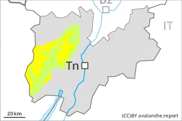
2600m
Avalanche Problem
Persistent weak layer
2600m
The avalanche prone locations are rare.
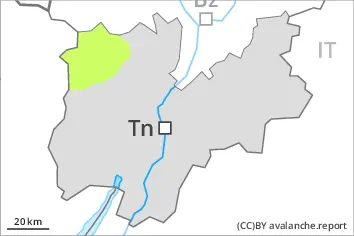
In isolated cases avalanches can be triggered in the weakly bonded old snow. Such avalanche prone locations are to be found in particular on extremely steep shady slopes above approximately 2600 m. Mostly avalanches are small. As a consequence of the moderate to strong southerly wind, snow drift accumulations formed on Tuesday. This applies especially on shady slopes in high Alpine regions. The wind slabs are mostly shallow and prone to triggering. These are clearly recognisable. Mostly avalanches are small. Apart from the danger of being buried, restraint should be exercised as well in view of the danger of avalanches sweeping people along and giving rise to falls.
Snowpack
Shady slopes above approximately 2600 m: Precarious weak layers exist in the bottom section of the snowpack. All aspects below approximately 2600 m: The snowpack is largely stable and its surface consists of loosely bonded snow lying on a crust. Some snow has fallen since yesterday over a wide area. Shady slopes above approximately 2600 m: The mostly small wind slabs are lying on soft layers. The new snow and wind slabs of the last few days are lying on a crust below approximately 2600 m. The snowpack remains subject to considerable local variations. In all regions less snow than usual is lying.
Tendency
The avalanche danger will persist.
Danger level
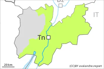
New snow, wind slabs and old snow require caution.
Fresh wind slabs require caution, in particular in the regions exposed to heavier precipitation. The wind slabs are mostly shallow and prone to triggering. These are clearly recognisable. Avalanches can in very isolated cases be released in the old snowpack. Such avalanche prone locations are to be found on very steep shady slopes at elevated altitudes. Apart from the danger of being buried, restraint should be exercised in particular in view of the danger of avalanches sweeping people along and giving rise to falls.
Snowpack
Some snow has fallen since yesterday over a wide area. Outgoing longwave radiation during the night was reduced. The snowpack will be in most cases stable. From a snow sport perspective, in most cases insufficient snow is lying.