Danger level
 | 2400m |
|  |
|  | ||||
| |
|  |


![]()
The wind slabs represent the main danger.
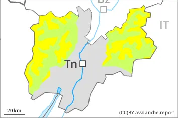
As a consequence of the strong to storm force northerly wind, fresh snow drift accumulations will form. This applies especially adjacent to ridgelines and in gullies and bowls. The wind slabs are bonding poorly with the old snowpack. The wind slabs of Tuesday are prone to triggering in all aspects above approximately 2400 m. The number and size of avalanche prone locations will increase with altitude.
Mostly avalanches are small.
In isolated cases avalanches can be triggered in the weakly bonded old snow. Such avalanche prone locations are to be found in particular on extremely steep shady slopes above approximately 2600 m.
In very isolated cases avalanches are medium-sized.
Even a small avalanche can sweep snow sport participants along and give rise to falls.
Snowpack
dp.6: cold, loose snow and wind
The fresh and older wind slabs are lying on soft layers in particular on shady slopes above approximately 2400 m.
In particular shady slopes, above approximately 2600 m: Faceted weak layers exist in the bottom section of the snowpack.
Steep south facing slopes: Hardly any snow is lying.
The snowpack will be generally subject to considerable local variations. Here only a small amount of snow is lying for the time of year in all altitude zones.
Tendency
As a consequence of a moderate to strong wind from northerly directions, further wind slabs will form on Wednesday. These represent the main danger.