Wind slabs and weakly bonded old snow require caution.
Distinct weak layers in the old snowpack can be released easily by individual winter sport participants especially in little used terrain. Remotely triggered avalanches are possible. Steep, little used shady slopes are to be avoided as far as possible. Mostly avalanches are medium-sized. Caution is to be exercised in particular on steep west, north and east facing slopes above the tree line. The avalanche prone locations are difficult to recognise. Whumpfing sounds and the formation of shooting cracks when stepping on the snowpack and fresh avalanches serve as an alarm indicating the danger.
Fresh and somewhat older wind slabs are prone to triggering, in particular in gullies and bowls, and behind abrupt changes in the terrain above approximately 2200 m. They are clearly recognisable to the trained eye.
Restraint is advisable.
Snowpack
dp.1: deep persistent weak layer dp.8: surface hoar blanketed with snow
Some snow will fall during the night. As a consequence of a strong wind from northerly directions, avalanche prone wind slabs will form especially in gullies and bowls. Somewhat older wind slabs are lying on surface hoar in some places.
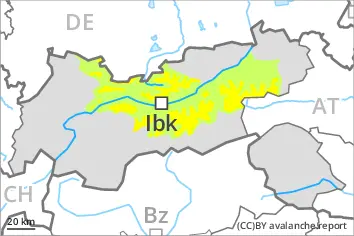
Above the tree line: The snowpack will be prone to triggering. Distinct weak layers exist in the old snowpack. This applies in particular on west, north and east facing slopes.
Tendency
Weak layers in the old snowpack represent the main danger. Restraint is appropriate.
Increase in avalanche danger as a consequence of new snow and wind, especially in the northwest. In particular in the north and in the northwest 10 to 20 cm of snow will fall on Monday. The mostly small wind slabs of the last few days will be covered with new snow in some cases and therefore difficult to recognise.
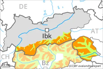
Danger level
treeline
Avalanche Problem
Persistent weak layer
Treeline
Wind slab
2200m
Wind slabs and weakly bonded old snow require caution.
Distinct weak layers in the old snowpack can be released easily by individual winter sport participants especially in little used terrain. Mostly avalanches are medium-sized. Caution is to be exercised in particular on steep west, north and east facing slopes above the tree line. The avalanche prone locations are difficult to recognise. Whumpfing sounds and the formation of shooting cracks when stepping on the snowpack serve as an alarm indicating the danger. Remotely triggered avalanches are possible in isolated cases. The avalanche situation is more favourable in highly frequented off-piste terrain.
The more recent wind slabs are in some cases prone to triggering above approximately 2200 m. They are to be found in particular adjacent to ridgelines and in gullies and bowls. The avalanche prone locations are sometimes covered with new snow and are therefore difficult to recognise.
Snowpack
dp.1: deep persistent weak layer dp.8: surface hoar blanketed with snow
5 to 15 cm of snow will fall until late morning. The wind will be light to moderate. The fresh wind slabs of the last few days will be covered with new snow in some cases and therefore difficult to recognise. They are lying on surface hoar in some places, in particular in places that are protected from the wind above approximately 2200 m.
Above the tree line: Distinct weak layers exist in the old snowpack. This applies in particular on west, north and east facing slopes. Field observations and avalanches triggered by explosives confirm the existence of a weak snowack.
Tendency
Increase in avalanche danger as a consequence of new snow and wind. Over a wide area 20 to 30 cm of snow will fall on Monday. The wind will be strong in some cases. As a consequence of the precipitation, the likelihood of slab avalanches being released will increase. The conditions are unfavourable for backcountry touring and other off-piste activities.
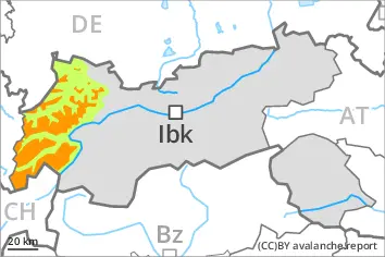
Danger level
treeline
Avalanche Problem
Persistent weak layer
Treeline
Wind slab
2200m
Weakly bonded old snow represents the main danger. In little used terrain a sometimes treacherous avalanche situation will prevail.
Distinct weak layers in the old snowpack can be released by individual winter sport participants especially in little used terrain. Mostly avalanches are medium-sized. Caution is to be exercised in particular on steep west, north and east facing slopes above the tree line. The avalanche prone locations are difficult to recognise. Whumpfing sounds and the formation of shooting cracks when stepping on the snowpack serve as an alarm indicating the danger. Remotely triggered avalanches are possible in isolated cases.
Since Thursday sometimes avalanche prone wind slabs formed in particular in gullies and bowls as well as above approximately 2200 m. They will be covered with new snow in some cases and therefore difficult to recognise.
Snowpack
dp.1: deep persistent weak layer dp.8: surface hoar blanketed with snow
5 to 15 cm of snow will fall until late morning. The wind will be light to moderate. The fresh wind slabs of the last few days will be covered with new snow in some cases and therefore difficult to recognise. They are lying on surface hoar in some places, in particular in places that are protected from the wind above approximately 2200 m.
Above the tree line: Distinct weak layers exist in the old snowpack. This applies in particular on west, north and east facing slopes.
Tendency
Gradual increase in avalanche danger as a consequence of new snow and wind. 10 to 20 cm of snow will fall on Monday. The wind will be strong in some cases. As a consequence of the precipitation, the likelihood of slab avalanches being released will increase.
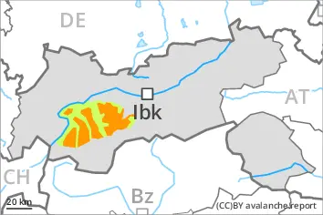
Danger level
2000m
Avalanche Problem
Persistent weak layer
2000m
Weak layers in the old snowpack can be released by individual winter sport participants in particular on steep shady slopes.
Avalanches can be released by a single winter sport participant. They can reach medium size. Caution is to be exercised in particular on steep west, north and east facing slopes above approximately 2000 m.
In addition the fresh wind slabs adjacent to ridgelines and in gullies and bowls are prone to triggering in some cases.
The number and size of avalanche prone locations will increase with altitude. Isolated whumpfing sounds can indicate the danger.
Snowpack
dp.1: deep persistent weak layer dp.6: cold, loose snow and wind
As a consequence of a sometimes strong northerly wind, further wind slabs will form in the course of the day. The wind slabs are lying on the unfavourable surface of an old snowpack at elevated altitudes.
Above approximately 2000 m: The snowpack will be prone to triggering. Distinct weak layers exist in the old snowpack. This applies in particular on west, north and east facing slopes.
Below approximately 2000 m as well as steep sunny slopes: The snowpack is fairly homogeneous and its surface has a crust that is barely capable of bearing a load.
Tendency
Avalanches can as before be released by a single winter sport participant.
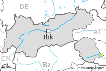
Danger level
treeline
Avalanche Problem
Persistent weak layer
Treeline
Wind slab
2200m
Weakly bonded old snow represents the main danger. Fresh wind slabs require caution.
Avalanches can in some places be released by a single winter sport participant, especially on steep west, north and east facing slopes above the tree line, and in little used backcountry terrain. Mostly avalanches are medium-sized. The avalanche prone locations are difficult to recognise. Isolated whumpfing sounds and shooting cracks when stepping on the snowpack can indicate the danger.
As a consequence of a sometimes strong wind from variable directions, mostly small wind slabs formed in the last few days as well, especially in places that are protected from the wind above approximately 2200 m. The wind slabs will be covered with new snow in some cases and therefore difficult to recognise.
Snowpack
dp.1: deep persistent weak layer dp.8: surface hoar blanketed with snow
5 to 15 cm of snow will fall until late morning. The wind will be light to moderate. The fresh wind slabs of the last few days will be covered with new snow in some cases and therefore difficult to recognise. They are lying on surface hoar in some places, in particular in places that are protected from the wind.
The old snowpack consists of faceted crystals. In its middle, the snowpack is weak in some cases.
The snowpack will be generally subject to considerable local variations. Only a small amount of snow is lying for the time of year in all altitude zones.
Tendency
In some regions increase in avalanche danger as a consequence of new snow and wind. Over a wide area 10 to 20 cm of snow will fall on Monday. The wind will be strong in some cases.
Danger level
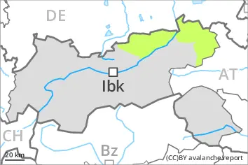
Low avalanche danger will prevail. Wind slabs require caution.
Individual avalanche prone locations for dry avalanches are to be found in particular on very steep shady slopes above approximately 2200 m and adjacent to ridgelines. The wind slabs are covered with new snow in some cases and therefore difficult to recognise.
Apart from the danger of being buried, restraint should be exercised as well in view of the danger of avalanches sweeping people along and giving rise to falls.
Snowpack
5 to 15 cm of snow will fall until late morning. The wind will be light to moderate.
The small wind slabs of Thursday are bonding only slowly with the old snowpack on very steep shady slopes above approximately 2200 m. They will be covered with new snow in some cases and therefore difficult to recognise. The old snowpack consists of faceted crystals.
The snowpack will be generally subject to considerable local variations. Only a little snow is lying in all altitude zones.
Tendency
In some regions increase in danger as a consequence of new snow and wind.