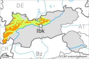
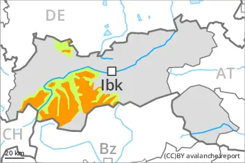
Outside marked and open pistes a very dangerous avalanche situation will prevail. From the late morning as a consequence of new snow and strong wind there will be an increase in the avalanche danger to level 4 (high). The danger exists in particular in alpine snow sports terrain.
The fresh snow and the wind slabs that are being formed by the strong westerly wind can be released easily or naturally in all aspects above the tree line. Individual avalanche prone locations are to be found also in areas close to the tree line. The number and size of avalanche prone locations will increase during the course of the night. As the snowfall level rises more frequent natural avalanches are to be expected from the late morning.
Avalanches can in some cases penetrate deep layers and reach large size. This applies on west, north and east facing slopes.
On very steep slopes small and, in isolated cases, medium-sized loose snow avalanches are possible. At low and intermediate altitudes small and, in isolated cases, medium-sized gliding avalanches and wet snow slides are to be expected as the snowfall level rises. In the regions exposed to rain this applies from late morning.
Snowpack
dp.1: deep persistent weak layer dp.8: surface hoar blanketed with snow
20 to 30 cm of snow fell during the night. 15 to 25 cm of snow, and even more in some localities, will fall until the evening. The wind will be strong.
The fresh snow and in particular the extensive wind slabs will be deposited on a weakly bonded old snowpack in particular on west, north and east facing slopes above the tree line. In some places various wind slab layers are lying on surface hoar. Faceted weak layers exist in the bottom section of the snowpack. Field observations and artificially triggered avalanches confirm the existence of a weak snowack.
Tendency
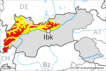
High avalanche danger will persist. The conditions are very dangerous for backcountry touring and other off-piste activities. Natural avalanches are to be expected.
Danger level
treeline
Avalanche Problem
Persistent weak layer
Treeline
Wind slab
Treeline
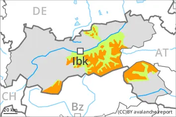
Wind slabs and weakly bonded old snow require caution.
Distinct weak layers in the old snowpack can be released easily by individual winter sport participants especially in little used terrain. Remotely triggered avalanches are possible. Steep, little used shady slopes are to be avoided as far as possible. Mostly avalanches are medium-sized. Caution is to be exercised in particular on steep west, north and east facing slopes above the tree line. The avalanche prone locations are difficult to recognise. Whumpfing sounds and the formation of shooting cracks when stepping on the snowpack and fresh avalanches serve as an alarm indicating the danger.
Fresh and somewhat older wind slabs are prone to triggering, in particular in gullies and bowls, and behind abrupt changes in the terrain above the tree line. They are clearly recognisable to the trained eye.
Restraint is advisable.
Snowpack
dp.1: deep persistent weak layer dp.8: surface hoar blanketed with snow
Some snow will fall. As a consequence of a strong wind from northwesterly directions, avalanche prone wind slabs will form especially in gullies and bowls. Somewhat older wind slabs are lying on surface hoar in some places.
Above the tree line: The snowpack will be prone to triggering. Distinct weak layers exist in the old snowpack. This applies in particular on west, north and east facing slopes.
Tendency
Weak layers in the old snowpack represent the main danger. Restraint is appropriate.
Some snow will fall.
Danger level
treeline
Avalanche Problem
Persistent weak layer
Treeline
Wind slab
Treeline
Natural avalanches are possible.
The off-piste conditions are dangerous. Wind slabs and weakly bonded old snow require caution.
The fresh snow and the wind slabs that are being formed by the strong westerly wind can be released very easily. The avalanche prone locations are to be found in particular in gullies and bowls, and behind abrupt changes in the terrain above the tree line. Individual avalanche prone locations are to be found also in areas close to the tree line. In some places avalanches can also penetrate near-ground layers of the snowpack and reach large size in isolated cases, in particular on west, north and east facing slopes. These places are difficult to recognise. Whumpfing sounds and the formation of shooting cracks when stepping on the snowpack and fresh avalanches serve as an alarm indicating the danger. Remotely triggered avalanches are possible.
As a consequence of the snowfall the avalanche prone locations will become more prevalent as the day progresses. Individual natural avalanches are to be expected.
At low and intermediate altitudes small wet loose snow slides are to be expected as a consequence of the rain, in particular on cut slopes, and on very steep grassy slopes.
Snowpack
dp.1: deep persistent weak layer dp.8: surface hoar blanketed with snow
Over a wide area 15 to 25 cm of snow, and even more in some localities, will fall on Monday. As a consequence of a strong wind from northwesterly directions, avalanche prone wind slabs will form. Somewhat older wind slabs are lying on surface hoar in some places.
The fresh snow and the wind slabs will be deposited on a weakly bonded old snowpack in particular on west, north and east facing slopes above the tree line. Faceted weak layers exist in the bottom section of the snowpack. Stability tests and reports filed by observers confirm the existence of a weak snowack.
Tendency
Further increase in avalanche danger as a consequence of new snow and wind. Weak layers in the old snowpack represent the main danger. Natural avalanches are to be expected.
Danger level
treeline
Avalanche Problem
Persistent weak layer
Treeline
Wind slab
Treeline
The off-piste conditions are unfavourable. Wind slabs and weakly bonded old snow require caution.
Distinct weak layers in the old snowpack can be released easily by individual winter sport participants especially in little used terrain. Caution is to be exercised in particular on steep west, north and east facing slopes above the tree line. The avalanche prone locations are difficult to recognise. Whumpfing sounds and the formation of shooting cracks when stepping on the snowpack and fresh avalanches serve as an alarm indicating the danger. Remotely triggered avalanches are possible. Mostly avalanches are medium-sized.
As a consequence of new snow and a strong northwesterly wind, easily released wind slabs will form in particular above the tree line, in particular in gullies and bowls, and behind abrupt changes in the terrain. Individual natural avalanches are to be expected.
Restraint is advisable.
Snowpack
dp.1: deep persistent weak layer dp.8: surface hoar blanketed with snow
Over a wide area 10 to 20 cm of snow will fall on Monday. As a consequence of a strong wind from northwesterly directions, avalanche prone wind slabs will form especially in gullies and bowls and behind abrupt changes in the terrain. Somewhat older wind slabs are lying on surface hoar in some places. Distinct weak layers exist in the old snowpack. This applies in particular on west, north and east facing slopes above the tree line.
Tendency
Weak layers in the old snowpack represent the main danger. Restraint is appropriate.
In some regions increase in avalanche danger as a consequence of new snow and wind. This applies in particular in the north and in the west.
Danger level
2000m
Avalanche Problem
Persistent weak layer
2000m
Wind slab
2200m
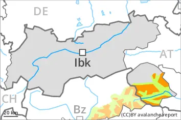
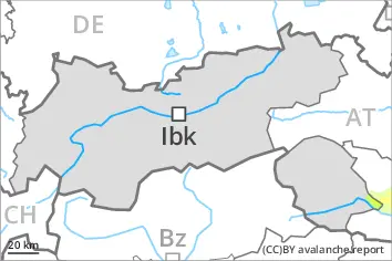
Weak layers in the old snowpack necessitate caution. Fresh wind slabs require caution.
Avalanches can be released in the weakly bonded old snow by a single winter sport participant. Caution is to be exercised in particular on steep west, north and east facing slopes above approximately 2000 m. Mostly avalanches are medium-sized. Isolated whumpfing sounds can indicate the danger.
As a consequence of new snow and a moderate to strong wind, avalanche prone wind slabs formed in particular adjacent to ridgelines and in gullies and bowls. This applies in particular above approximately 2200 m. The fresh wind slabs can be released by a single winter sport participant, but they will be small in most cases.
The number and size of avalanche prone locations will increase with altitude.
Snowpack
dp.1: deep persistent weak layer dp.6: cold, loose snow and wind
Some snow has fallen in some regions. As a consequence of a moderate to strong wind from northerly directions, sometimes avalanche prone wind slabs formed. The wind slabs are lying on surface hoar in some places at elevated altitudes.
Above approximately 2000 m: The snowpack will be prone to triggering. Distinct weak layers exist in the old snowpack. This applies in particular on west, north and east facing slopes.
Little snow will fall on Monday.
Tendency
Avalanches can be released by a single winter sport participant.
Danger level
treeline
Avalanche Problem
Wind slab
Treeline
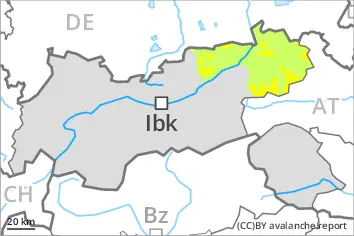
Fresh wind slabs require caution.
Avalanches can in some places be released by a single winter sport participant. The avalanche prone locations are to be found adjacent to ridgelines and in gullies and bowls above the tree line. Avalanches can in isolated cases reach medium size. The avalanche prone locations are barely recognisable because of the poor visibility. Shooting cracks when stepping on the snowpack can indicate the danger.
Snowpack
dp.6: cold, loose snow and wind dp.8: surface hoar blanketed with snow
5 to 15 cm of snow will fall on Monday. The wind will be strong adjacent to ridgelines.
The fresh wind slabs will be deposited on soft layers. Older wind slabs are lying on surface hoar in some places, in particular in places that are protected from the wind.
The snowpack will be generally subject to considerable local variations. Only a small amount of snow is lying for the time of year in all altitude zones.
Tendency
As a consequence of new snow and wind there will be an increase in the danger within the current danger level. 10 to 20 cm of snow will fall on Tuesday. The wind will be strong adjacent to ridgelines.