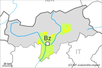
Danger level
 | treeline |
|  |
|  | ||||
| |
|  |


![]()
Wind slabs and weakly bonded old snow require caution.
Distinct weak layers in the old snowpack can be released easily by individual winter sport participants especially in little used terrain. Remotely triggered avalanches are possible. Steep, little used shady slopes are to be avoided as far as possible. Mostly avalanches are medium-sized. Caution is to be exercised in particular on steep west, north and east facing slopes above the tree line. The avalanche prone locations are difficult to recognise. Whumpfing sounds and the formation of shooting cracks when stepping on the snowpack and fresh avalanches serve as an alarm indicating the danger.
Fresh and somewhat older wind slabs are prone to triggering, in particular in gullies and bowls, and behind abrupt changes in the terrain above approximately 2200 m. They are clearly recognisable to the trained eye.
Restraint is advisable.
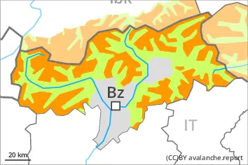
Snowpack
dp.1: deep persistent weak layer
dp.8: surface hoar blanketed with snow
Some snow will fall during the night. As a consequence of a strong wind from northerly directions, avalanche prone wind slabs will form especially in gullies and bowls. Somewhat older wind slabs are lying on surface hoar in some places.
Above the tree line: The snowpack will be prone to triggering. Distinct weak layers exist in the old snowpack. This applies in particular on west, north and east facing slopes.
Tendency
Weak layers in the old snowpack represent the main danger. Restraint is appropriate.
Increase in avalanche danger as a consequence of new snow and wind, especially in the northwest. In particular in the north and in the northwest 10 to 20 cm of snow will fall on Monday. The mostly small wind slabs of the last few days will be covered with new snow in some cases and therefore difficult to recognise.