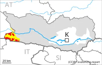
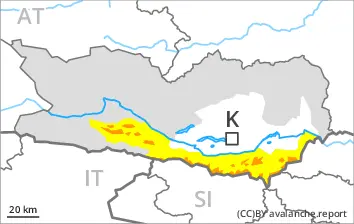
A very dangerous avalanche situation will prevail. The danger exists in particular in alpine snow sports terrain.
The large quantity of fresh snow and the extensive wind slabs that are being formed by the strong westerly wind are very prone to triggering in all aspects above the tree line. Such avalanche prone locations are to be found also in areas close to the tree line.
As a consequence of new snow and wind natural avalanches are to be expected until late in the night. Avalanches can in some cases penetrate deep layers and reach large size. This applies on west, north and east facing slopes.
With the end of the snowfall, the natural avalanche activity will slowly decrease. In particular in the regions exposed to the foehn wind more natural avalanches are possible as a consequence of the strong to storm force northwesterly wind. Caution is to be exercised in particular in leeward starting zones.
Snowpack
dp.1: deep persistent weak layer dp.6: cold, loose snow and wind
In some regions 10 to 20 cm of snow will fall until late morning. The wind will be moderate to strong. The wind will be storm force at times in particular in the Southern Zillertal Alps and High Tauern and along the border with South Tyrol. The wind will transport the new snow. Further wind slabs will form.
The snowpack will be prone to triggering over a wide area. The new snow and wind slabs are lying on top of a weakly bonded old snowpack. Somewhat older wind slabs are lying on surface hoar. Distinct weak layers exist in the bottom section of the old snowpack. This applies in particular on west, north and east facing slopes above the tree line.
Tendency
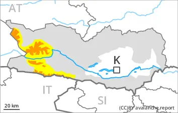
Some snow will fall in some regions. The rain will give rise to softening of the snowpack at low and intermediate altitudes. As a consequence of a sometimes storm force wind from westerly directions, further wind slabs will form on Saturday. The snow sport conditions outside marked and open pistes remain very dangerous. Avalanches can be released very easily. More natural avalanches are possible.
Danger level
treeline
Avalanche Problem
Persistent weak layer
Treeline
Wind slab
Treeline
New snow
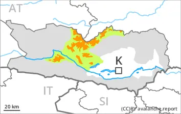
The conditions are very dangerous for winter sport activities outside marked and open pistes. Remotely triggered and natural avalanches are to be expected.
The conditions are very dangerous for winter sport activities outside marked and open pistes. Remotely triggered and natural avalanches are to be expected.
Wind slabs are very prone to triggering in all aspects. These can be released in near-surface layers of the snowpack. Avalanches can also penetrate near-ground layers of the snowpack and reach large size on west, north and east facing slopes. Natural avalanches are to be expected. This applies especially at the base of rock walls and behind abrupt changes in the terrain. Caution is to be exercised, including in areas close to the tree line. The runout zones are to be avoided.
In addition an appreciable danger of loose snow avalanches exists.
Snowpack
dp.1: deep persistent weak layer dp.8: surface hoar blanketed with snow
30 to 50 cm of snow, and even more in some localities, has fallen since Thursday. The northwesterly wind will transport the new snow. Over a wide area further wind slabs will form. Somewhat older wind slabs are lying on surface hoar in some places. The snowpack will become increasingly prone to triggering. Distinct weak layers exist in the old snowpack in particular on west, north and east facing slopes.
Tendency
The snowpack remains prone to triggering. As a consequence of warming, the likelihood of avalanches being released will increase.
Danger level
treeline
Avalanche Problem
Persistent weak layer
Treeline
Wind slab
Treeline
New snow
The conditions are dangerous for winter sport activities outside marked and open pistes. Remotely triggered and natural avalanches are to be expected.
The conditions are dangerous for winter sport activities outside marked and open pistes. Remotely triggered and natural avalanches are to be expected.
Wind slabs are very prone to triggering in all aspects. These can be released in near-surface layers of the snowpack. Avalanches can also penetrate near-ground layers of the snowpack and reach medium size on west, north and east facing slopes. Natural avalanches are to be expected. This applies especially at the base of rock walls and behind abrupt changes in the terrain. Caution is to be exercised, including in areas close to the tree line. The runout zones are to be avoided.
In addition an appreciable danger of loose snow avalanches exists.
Snowpack
dp.1: deep persistent weak layer dp.8: surface hoar blanketed with snow
20 to 30 cm of snow, and even more in some localities, has fallen since Thursday. The northwesterly wind will transport the new snow. Over a wide area further wind slabs will form. Somewhat older wind slabs are lying on surface hoar in some places. The snowpack will become increasingly prone to triggering. Distinct weak layers exist in the old snowpack in particular on west, north and east facing slopes.
Tendency
The snowpack remains prone to triggering. As a consequence of warming, the likelihood of avalanches being released will increase.
Danger level
treeline
Avalanche Problem
Wind slab
Treeline
Persistent weak layer
Treeline
Wet snow
Treeline
An unfavourable avalanche situation will prevail.
Wind slabs can be released easily. or in isolated cases naturally, above the tree line. Avalanches can also penetrate near-ground layers of the snowpack and reach medium size on west, north and east facing slopes. The runout zones are to be avoided. Remotely triggered avalanches are possible.
Mostly small wet loose snow avalanches are possible. In the event of rain this applies in particular on very steep slopes in the Karawanks West, in the Karwanks Central and in the Karwanks East.
Snowpack
dp.1: deep persistent weak layer dp.6: cold, loose snow and wind
20 to 40 cm of snow has fallen. 5 to 10 cm of snow, and even more in some localities, will fall. Above the tree line: The strong wind will transport the new snow. Somewhat older wind slabs are lying on surface hoar in some places. Over a wide area further wind slabs will form. The snowpack will become increasingly prone to triggering. Distinct weak layers exist in the old snowpack in particular on west, north and east facing slopes.
Below the tree line: Karawanks West, Karwanks Central, Karawanks East, The rain will give rise to thorough wetting of the snowpack.
Tendency
The snowpack remains prone to triggering. As a consequence of warming, the likelihood of avalanches being released will increase.
Danger level
treeline
Avalanche Problem
Persistent weak layer
Treeline
Wind slab
Treeline
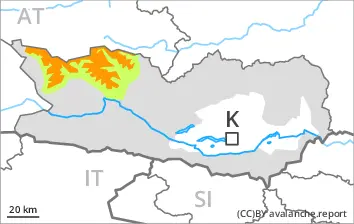
An unfavourable avalanche situation will prevail.
Wind slabs are prone to triggering in all aspects. These can be released in near-surface layers of the snowpack. Avalanches can also penetrate near-ground layers of the snowpack and reach medium size on west, north and east facing slopes. Individual natural avalanches are possible.
Snowpack
dp.1: deep persistent weak layer dp.6: cold, loose snow and wind
15 to 25 cm of snow, and even more in some localities, has fallen since Thursday. The northwesterly wind will transport the new snow. Over a wide area further wind slabs will form. Somewhat older wind slabs are lying on surface hoar in some places. The snowpack will become increasingly prone to triggering. Distinct weak layers exist in the old snowpack in particular on west, north and east facing slopes.
Tendency
The snowpack remains prone to triggering. As a consequence of warming, the likelihood of avalanches being released will increase.
Danger level
treeline
Avalanche Problem
Persistent weak layer
Treeline
Wind slab
Treeline
Remotely triggered and natural avalanches are possible.
A precarious avalanche situation will prevail. The avalanche danger in the regions exposed to heavier precipitation is within the upper range of danger level 3 (considerable).
Wind slabs are very prone to triggering in all aspects. These can in many cases be released in near-surface layers of the snowpack. Avalanches can also penetrate near-ground layers of the snowpack and reach quite a large size on west, north and east facing slopes. As a consequence of a strong to storm force wind from northwesterly directions, further wind slabs will form in the course of the day. Natural avalanches are to be expected. The runout zones are to be avoided.
Snowpack
dp.1: deep persistent weak layer dp.6: cold, loose snow and wind
15 to 30 cm of snow, and even more in some localities, has fallen since Thursday. The northwesterly wind will transport the new snow. Somewhat older wind slabs are lying on surface hoar. Over a wide area further wind slabs will form. The snowpack will become increasingly prone to triggering. Distinct weak layers exist in the old snowpack in particular on west, north and east facing slopes.
Tendency
The snowpack remains prone to triggering. As a consequence of warming, the likelihood of avalanches being released will increase.
Danger level
treeline
Avalanche Problem
Wind slab
Treeline
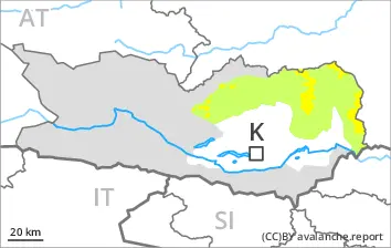
Wind slabs require caution.
In particular on wind-loaded slopes avalanches can be triggered in the faceted old snow. This applies even in case of a single winter sport participant in some cases. In very isolated cases avalanches are medium-sized. Caution is to be exercised in particular on west, north and east facing slopes above the tree line.
Snowpack
dp.6: cold, loose snow and wind dp.1: deep persistent weak layer
5 to 10 cm of snow, and even more in some localities, has fallen. 10 to 20 cm of snow, and even more in some localities, will fall. The sometimes strong wind will transport the new snow. Distinct weak layers exist in the old snowpack in particular on west, north and east facing slopes.