Remotely triggered and natural avalanches are possible.
Outside marked and open pistes a dangerous avalanche situation will prevail. The danger exists in particular in alpine snow sports terrain.
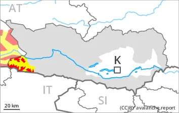
Wind slabs are very prone to triggering in all aspects above the tree line, caution is to be exercised, including in areas close to the tree line. Avalanches can be released in near-surface layers of the snowpack. Additionally avalanches can also penetrate near-ground layers of the snowpack and reach large size on west, north and east facing slopes. Whumpfing sounds and the formation of shooting cracks when stepping on the snowpack and fresh avalanches serve as an alarm indicating the danger. Remotely triggered avalanches are possible.
As a consequence of the strong to storm force foehn wind from the north more natural avalanches are possible. This applies in case of releases originating from very steep leeward starting zones, in particular at the base of rock walls and behind abrupt changes in the terrain.
As a consequence of warming during the day and solar radiation wet small and medium sized avalanches are possible. This applies especially on very steep slopes.
Snowpack
dp.1: deep persistent weak layer dp.6: cold, loose snow and wind
20 to 40 cm of snow, and up to 60 cm in some localities, has fallen since Thursday. Thus far the wind has been strong to storm force. Some snow will fall. This applies in particular in the north. The wind will transport the new snow. Further wind slabs will form.
The snowpack will be prone to triggering over a wide area. The new snow and wind slabs are lying on top of a weakly bonded old snowpack. Somewhat older wind slabs are lying on surface hoar in some places. Distinct weak layers exist in the bottom section of the old snowpack. This applies in particular on west, north and east facing slopes above the tree line.
The weather conditions as the day progresses will give rise to moistening of the snowpack.
Tendency
The off-piste conditions remain dangerous.
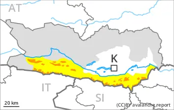
Danger level
treeline
Avalanche Problem
Persistent weak layer
Treeline
New snow
Treeline
Wet snow
1800m
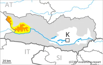
Natural avalanches are to be expected.
A very dangerous avalanche situation will prevail. The danger exists in particular in alpine snow sports terrain.
Large quantities of fresh snow and the wind-drifted snow are lying on top of a weakly bonded old snowpack. The fresh snow and the extensive wind slabs that are being formed by the strong westerly wind are very prone to triggering in all aspects above the tree line. The avalanche prone locations are numerous. They are to be found also in steep terrain in areas close to the tree line.
More natural avalanches are to be expected. Avalanches can in some cases penetrate deep layers and reach large size. This applies on west, north and east facing slopes.
With the onset of the intense precipitation, the natural avalanche activity will increase. Caution is to be exercised in particular in leeward starting zones. As a consequence of the rain, the likelihood of natural avalanches being released will increase significantly.
Snowpack
dp.1: deep persistent weak layer dp.6: cold, loose snow and wind
20 to 30 cm of snow, and even more in some localities, has fallen since Thursday. 20 to 30 cm of snow, and even more in some localities, will fall on Saturday, this applies in particular as the day progresses. The wind will be moderate to strong. The wind will transport the new snow. Further wind slabs will form. Up to intermediate altitudes rain will fall.
The snowpack will be prone to triggering over a wide area. The new snow and wind slabs are lying on top of a weakly bonded old snowpack. Somewhat older wind slabs are lying on surface hoar. Distinct weak layers exist in the bottom section of the old snowpack. This applies in particular on west, north and east facing slopes above the tree line.
Tendency
Some snow will fall in some regions. The rain will give rise to softening of the snowpack at low and intermediate altitudes. As a consequence of a sometimes storm force wind from westerly directions, further wind slabs will form on Saturday. The snow sport conditions outside marked and open pistes remain very dangerous. Avalanches can be released very easily. More natural avalanches are possible.
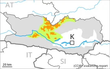
Danger level
treeline
Avalanche Problem
Persistent weak layer
Treeline
Wind slab
Treeline
Wet snow
1800m
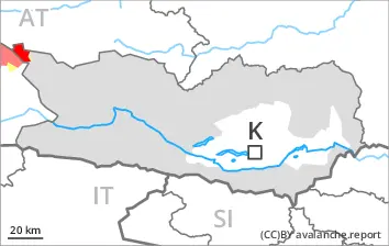
An unfavourable avalanche situation will prevail. As a consequence of the strong foehn wind from the north more natural avalanches are possible as the day progresses.
Wind slabs are very prone to triggering in all aspects. These can be released in near-surface layers of the snowpack. Avalanches can also penetrate near-ground layers of the snowpack and reach medium size on west, north and east facing slopes. As a consequence of the strong foehn wind from the north individual natural avalanches are possible as the day progresses. This applies especially at the base of rock walls and behind abrupt changes in the terrain. The runout zones are to be avoided.
In addition an appreciable danger of loose snow avalanches exists.
Snowpack
dp.1: deep persistent weak layer dp.8: surface hoar blanketed with snow
20 to 30 cm of snow, and even more in some localities, has fallen since Thursday. The northerly foehn wind will transport the new snow. Over a wide area further wind slabs will form. Somewhat older wind slabs are lying on surface hoar in some places. Distinct weak layers exist in the old snowpack in particular on west, north and east facing slopes.
Tendency
The conditions remain unfavourable. As a consequence of warming, the likelihood of moist avalanches being released will increase.
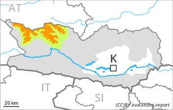
Danger level
treeline
Avalanche Problem
Persistent weak layer
Treeline
Wind slab
Treeline
Wet snow
1800m
A sometimes unfavourable avalanche situation will prevail.
Wind slabs can be released by a single winter sport participant above the tree line. Avalanches can also penetrate near-ground layers of the snowpack and reach medium size on west, north and east facing slopes. Remotely triggered avalanches are possible in isolated cases. Very isolated medium-sized natural avalanches are not entirely ruled out.
As a consequence of warming during the day and solar radiation mostly small moist loose snow avalanches are possible.
Snowpack
dp.1: deep persistent weak layer dp.6: cold, loose snow and wind
30 to 50 cm of snow, and even more in some localities, has fallen. Above the tree line: The strong wind will transport the new snow. Somewhat older wind slabs are lying on surface hoar in some places. Further wind slabs will form. Distinct weak layers exist in the old snowpack in particular on west, north and east facing slopes.
The weather conditions as the day progresses will give rise to moistening of the snowpack.
Tendency
The snowpack remains prone to triggering at elevated altitudes. As a consequence of warming, the likelihood of moist avalanches being released will increase.
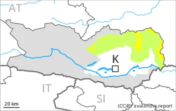
Danger level
treeline
Avalanche Problem
Persistent weak layer
Treeline
Wind slab
Treeline
Fresh wind slabs are to be avoided.
Wind slabs are prone to triggering in all aspects. These can be released in near-surface layers of the snowpack. The avalanche prone locations are clearly recognisable to the trained eye. Avalanches can in some cases penetrate near-ground layers of the snowpack and reach medium size on west, north and east facing slopes. Individual natural avalanches are possible. In the regions exposed to a lot of wind this applies at the base of rock walls and behind abrupt changes in the terrain.
Snowpack
dp.1: deep persistent weak layer dp.6: cold, loose snow and wind
15 to 25 cm of snow, and even more in some localities, has fallen. The northerly foehn wind will transport the new snow. Over a wide area further wind slabs will form. Somewhat older wind slabs are lying on surface hoar in some places. Distinct weak layers exist in the old snowpack in particular on west, north and east facing slopes.
Tendency
The snowpack remains prone to triggering. As a consequence of warming, the likelihood of moist avalanches being released will increase.
Danger level
treeline
Avalanche Problem
Persistent weak layer
Treeline
Wind slab
Treeline
Remotely triggered and natural avalanches are possible.
A precarious avalanche situation will prevail.
Wind slabs are very prone to triggering in all aspects. These can in many cases be released in near-surface layers of the snowpack. Avalanches can also penetrate near-ground layers of the snowpack and reach medium size on west, north and east facing slopes. As a consequence of the strong foehn wind from the north individual natural avalanches are possible as the day progresses. The runout zones are to be avoided. In addition as the day progresses especially at the base of rock walls, small loose snow avalanches are possible.
Snowpack
dp.1: deep persistent weak layer dp.6: cold, loose snow and wind
15 to 30 cm of snow, and even more in some localities, has fallen. Some snow will fall in the afternoon. The northerly foehn wind will transport the new snow. Somewhat older wind slabs are lying on surface hoar. Over a wide area further wind slabs will form. Distinct weak layers exist in the old snowpack in particular on west, north and east facing slopes.
Tendency
The snowpack remains prone to triggering. As a consequence of warming, the likelihood of moist avalanches being released will increase.
Danger level
treeline
Avalanche Problem
Wind slab
Treeline
Wind slabs require caution.
In particular on wind-loaded slopes avalanches can be triggered in the faceted old snow. This applies even in case of a single winter sport participant in some cases. In very isolated cases avalanches are medium-sized. Caution is to be exercised in particular on west, north and east facing slopes above the tree line.
Snowpack
dp.6: cold, loose snow and wind dp.1: deep persistent weak layer
20 to 40 cm of snow has fallen. The strong wind will transport the new snow. Distinct weak layers exist in the old snowpack in particular on west, north and east facing slopes.