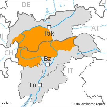
Backcountry touring and other off-piste activities call for great restraint.
Weakly bonded old snow and gliding snow require caution. In particular steep sunny slopes: Further increase in danger of wet avalanches as a consequence of warming.
In particular on very steep slopes medium-sized natural avalanches must be expected. In some places the avalanches can penetrate down to the ground and reach large size. Mostly the dry avalanches are medium-sized and can be released by a single winter sport participant. Remotely triggered avalanches are possible. Whumpfing sounds and the formation of shooting cracks when stepping on the snowpack serve as an alarm indicating the danger. The avalanche prone locations are prevalent and are barely recognisable, even to the trained eye. Backcountry touring calls for meticulous route selection. Avalanches can be released in the old snowpack and reach large size in isolated cases. This applies even in case of a single winter sport participant. Caution is to be exercised in particular in little used terrain, as well as at transitions from a shallow to a deep snowpack, when entering gullies and bowls for example. In their paths avalanches can entrain the wet snow. This extends the avalanche runout distances. The no longer entirely fresh wind slabs remain for the foreseeable future prone to triggering in particular on steep west, north and east facing slopes above approximately 2400 m. As a consequence of warming during the day and solar radiation wet avalanches are to be expected. This applies in particular on very steep sunny slopes, and at the base of rock walls. The runout zones are to be treated with caution.
Snowpack
dp.1: deep persistent weak layer dp.10: springtime scenario
Distinct weak layers exist in the bottom section of the old snowpack. The meteorological conditions will foster a gradual weakening of the snowpack on sunny slopes. The snowpack remains unstable over a wide area, especially adjacent to ridgelines and in pass areas in all altitude zones, as well as in gullies and bowls, and behind abrupt changes in the terrain at elevated altitudes.
Tendency
The snowpack remains prone to triggering over a wide area. The avalanche danger will persist. The activity of wet avalanches will gradually increase.
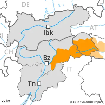
EARLIER Danger level
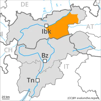
1800m
Avalanche Problem
Persistent weak layer
1800m
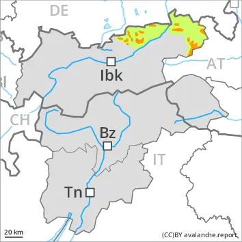
LATER Danger level
1800m
Avalanche Problem
Persistent weak layer
1800m
Wet snow
2600m
Weakly bonded old snow requires caution. Increase in danger of wet avalanches in the course of the day.
Avalanches can be released in the old snowpack and reach large size in particular on west, north and east facing slopes. This applies even in case of a single winter sport participant. The avalanche prone locations are to be found especially on west, north and east facing slopes above approximately 1800 m and in all aspects at elevated altitudes. Caution is to be exercised in particular at transitions from a shallow to a deep snowpack. Whumpfing sounds can indicate the danger. Remotely triggered avalanches are possible. As a consequence of warming natural avalanches are possible. In their paths avalanches can entrain the wet snow. This extends the avalanche runout distances.
As a consequence of warming during the day and solar radiation wet avalanches are to be expected. This applies in particular on very steep sunny slopes below approximately 2600 m, as well as at the base of rock walls. In particular on steep, rather lightly snow-covered east and west facing slopes the wet avalanches can penetrate even deep layers and reach quite a large size. The runout zones are to be treated with caution.
Snowpack
dp.1: deep persistent weak layer dp.10: springtime scenario
On Saturday it will be very mild over a wide area.
Shady slopes: The snowpack remains prone to triggering in some places. Distinct weak layers exist in the old snowpack in particular on west, north and east facing slopes.
Outgoing longwave radiation during the night will be good. The surface of the snowpack will freeze to form a strong crust and will soften during the day. Sunshine and high temperatures will give rise as the day progresses to thorough wetting of the snowpack in particular on steep sunny slopes below approximately 2600 m. This also applies at the base of rock walls.
Tendency
In the course of the day the activity of wet avalanches will increase. Weakly bonded old snow requires caution.
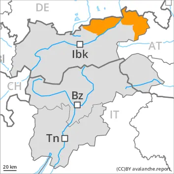
EARLIER Danger level
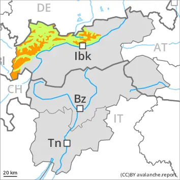
2000m
Avalanche Problem
Persistent weak layer
2000m
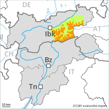
LATER Danger level
2000m
Avalanche Problem
Persistent weak layer
2000m
Wet snow
2600m
Weakly bonded old snow and wet snow represent the main danger.
Avalanches can be released in the old snowpack and reach large size in isolated cases on west, north and east facing slopes. This applies even in case of a single winter sport participant in some cases. The avalanche prone locations are to be found in particular above approximately 2000 m. Individual avalanche prone locations are to be found also on steep sunny slopes at elevated altitudes. Caution is to be exercised in particular at transitions from a shallow to a deep snowpack. In their paths avalanches can entrain the wet snow. This extends the avalanche runout distances. Whumpfing sounds can indicate the danger. Remotely triggered avalanches are possible in isolated cases.
As a consequence of warming during the day and solar radiation wet avalanches are to be expected. This applies in particular on very steep sunny slopes below approximately 2600 m, as well as at the base of rock walls. The runout zones are to be treated with caution.
Snowpack
dp.1: deep persistent weak layer dp.10: springtime scenario
On Saturday it will be very mild over a wide area.
Shady slopes: The snowpack remains prone to triggering in some places. Distinct weak layers exist in the old snowpack in particular on west, north and east facing slopes.
Outgoing longwave radiation during the night will be good. The surface of the snowpack will freeze to form a strong crust and will soften during the day. Sunshine and high temperatures will give rise as the day progresses to thorough wetting of the snowpack in particular on steep sunny slopes below approximately 2600 m. This also applies at the base of rock walls.
Tendency
In the course of the day the activity of wet avalanches will increase. Weakly bonded old snow requires caution.
EARLIER Danger level
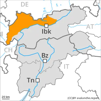
treeline
Avalanche Problem
Persistent weak layer
Treeline
LATER Danger level
treeline
Avalanche Problem
Persistent weak layer
Treeline
Wet snow
Weakly bonded old snow requires caution. Increase in danger of wet avalanches in the course of the day.
Even single winter sport participants can release avalanches in some places. In particular shady slopes are dangerous, especially in areas close to the tree line, as well as above the tree line.
As a consequence of warming during the day and solar radiation loose snow avalanches are to be expected as the day progresses. This applies in particular on steep sunny slopes.
In addition gliding avalanches are possible. This applies especially on cut and grassy slopes.
Snowpack
dp.1: deep persistent weak layer dp.10: springtime scenario
The weather will be very mild over a wide area. Shady slopes: The snowpack remains prone to triggering in some places. Large quantities of fresh snow and the wind-drifted snow of the last few days are bonding only slowly with the old snowpack in particular on shady slopes. As a consequence of mild temperatures the snow drift accumulations stabilised.
The surface of the snowpack will freeze to form a strong crust and will soften during the day. Sunshine and high temperatures will give rise as the day progresses to extreme and thorough wetting of the snowpack in particular on steep sunny slopes.
Tendency
Little snow will fall. Avalanches can be released in the weakly bonded old snow by a single winter sport participant. The surface of the snowpack will cool hardly at all during the overcast night and will already be soft in the early morning. The danger of wet snow slides and avalanches will already exist in the early morning.
EARLIER Danger level
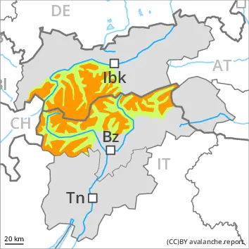
1800m
Avalanche Problem
Persistent weak layer
1800m
LATER Danger level
1800m
Avalanche Problem
Persistent weak layer
1800m
Wet snow
2400m
Weakly bonded old snow and wet snow represent the main danger.
Distinct weak layers exist in the bottom section of the snowpack in particular on west, north and east facing slopes. Winter sport participants can release avalanches in many places. These can reach large size. The avalanche prone locations are to be found on slopes above approximately 1800 m. Individual avalanche prone locations are to be found also on southeast, south and southwest facing slopes above approximately 2400 m. Caution is to be exercised in particular in little used terrain, as well as at transitions from a shallow to a deep snowpack, when entering gullies and bowls for example. Remotely triggered avalanches are possible. Whumpfing sounds serve as an alarm indicating the danger. In their paths avalanches can entrain the wet snow. This extends the avalanche runout distances.
As a consequence of warming during the day and solar radiation more wet avalanches are to be expected as the day progresses. This applies in particular on steep sunny slopes below approximately 2400 m. In particular on steep, rather lightly snow-covered east and west facing slopes the wet avalanches can penetrate even deep layers and reach large size in isolated cases.
In addition gliding avalanches are possible. This applies especially on cut and grassy slopes below approximately 2400 m.
Snowpack
dp.1: deep persistent weak layer dp.10: springtime scenario
The weather will be very mild over a wide area. The snowpack remains prone to triggering over a wide area. Avalanche prone weak layers exist in the bottom section of the snowpack on west, north and east facing slopes.
Steep sunny slopes: The surface of the snowpack will freeze to form a strong crust and will soften during the day. Sunshine and high temperatures will give rise as the day progresses to a loss of strength within the snowpack in particular on steep sunny slopes below approximately 2400 m.
Tendency
Avalanches can be released in the weakly bonded old snow by a single winter sport participant. The surface of the snowpack will cool hardly at all during the overcast night and will already be soft in the early morning. The danger of wet snow slides and avalanches will already exist in the early morning.
EARLIER Danger level
2000m
Avalanche Problem
Persistent weak layer
2000m
LATER Danger level
2000m
Avalanche Problem
Persistent weak layer
2000m
Wet snow
2400m
Weakly bonded old snow and wet snow represent the main danger.
Distinct weak layers exist in the bottom section of the snowpack in particular above approximately 2000 m. Winter sport participants can release avalanches in some places. These can penetrate deep layers and reach large size, especially on west, north and east facing slopes. Individual avalanche prone locations are to be found also on southeast, south and southwest facing slopes above approximately 2400 m. Caution is to be exercised in particular at transitions from a shallow to a deep snowpack, when entering gullies and bowls for example. Remotely triggered avalanches are possible.
As a consequence of warming during the day and solar radiation more wet avalanches are to be expected as the day progresses. This applies in particular on steep sunny slopes below approximately 2400 m. In particular on steep, rather lightly snow-covered east and west facing slopes the wet avalanches can penetrate even deep layers and reach large size in isolated cases.
In addition gliding avalanches are possible. This applies especially on cut and grassy slopes below approximately 2400 m.
Snowpack
dp.7: snow-poor zones in snow-rich surrounding dp.10: springtime scenario
The weather will be very warm. The snowpack remains prone to triggering. Avalanche prone weak layers exist in the bottom section of the snowpack on west, north and east facing slopes.
The surface of the snowpack will freeze to form a strong crust and will soften during the day. Sunshine and high temperatures will give rise as the day progresses to extreme and thorough wetting of the snowpack in particular on steep sunny slopes below approximately 2400 m.
Tendency
Little snow will fall. Avalanches can be released in the weakly bonded old snow by a single winter sport participant. The surface of the snowpack will cool hardly at all during the overcast night and will already be soft in the early morning. The danger of wet snow slides and avalanches will already exist in the early morning.
EARLIER Danger level
2000m
Avalanche Problem
Persistent weak layer
2000m
LATER Danger level
2000m
Avalanche Problem
Persistent weak layer
2000m
Wet snow
2400m
Weakly bonded old snow requires caution. The danger of wet avalanches will increase significantly during the day.
Avalanches can in many cases be released in the old snowpack and reach large size. This applies even in case of a single winter sport participant. The avalanche prone locations are to be found in particular on steep west, north and east facing slopes above approximately 2000 m. Individual avalanche prone locations are to be found also on steep sunny slopes above approximately 2400 m. Caution is to be exercised in particular in little used terrain, as well as at transitions from a shallow to a deep snowpack, when entering gullies and bowls for example. In their paths avalanches can entrain the wet snow. This extends the avalanche runout distances. Remotely triggered avalanches are possible. Whumpfing sounds and the formation of shooting cracks when stepping on the snowpack serve as an alarm indicating the danger.
As a consequence of warming during the day and solar radiation wet avalanches are to be expected. This applies in particular on very steep sunny slopes, and at the base of rock walls. The runout zones are to be treated with caution.
Snowpack
dp.1: deep persistent weak layer dp.10: springtime scenario
Distinct weak layers exist in the old snowpack in particular on west, north and east facing slopes.
Outgoing longwave radiation during the night will be good over a wide area. Sunshine and high temperatures will give rise as the day progresses to rapid and thorough wetting of the snowpack. This applies especially on steep sunny slopes below approximately 2400 m.
Tendency
Avalanches can be released in the weakly bonded old snow by a single winter sport participant. The danger of wet snow slides and avalanches will already exist in the early morning, after an overcast night especially on the Main Alpine Ridge and to the north. In the other regions the danger of wet avalanches will increase during the day, in particular on steep sunny slopes at intermediate and high altitudes.
EARLIER Danger level
treeline
Avalanche Problem
Persistent weak layer
Treeline
Wet snow
LATER Danger level
treeline
Avalanche Problem
Persistent weak layer
Treeline
Wet snow
1500m
Wet snow
1500m
Weak layers in the old snowpack can be released in isolated cases. The danger of wet avalanches will increase during the day.
Avalanches can in isolated cases be released in the old snowpack and reach medium size on west, north and east facing slopes. This applies in case of a single winter sport participant. In their paths avalanches can entrain the wet snow.
As a consequence of warming during the day and solar radiation individual small and medium-sized wet avalanches are to be expected.
Snowpack
dp.1: deep persistent weak layer dp.10: springtime scenario
Distinct weak layers exist in the old snowpack in particular on west, north and east facing slopes.
Outgoing longwave radiation during the night will be good over a wide area. Sunshine and high temperatures will give rise as the day progresses to rapid and thorough wetting of the snowpack.
Tendency
Weakly bonded old snow and wet snow require caution.
Danger level
treeline
Avalanche Problem
Persistent weak layer
Treeline
Wet snow
Weak layers in the old snowpack can be released in isolated cases. The danger of wet avalanches will increase during the day.
Avalanches can in isolated cases be released in the old snowpack and reach medium size on west, north and east facing slopes. This applies in case of a single winter sport participant. In their paths avalanches can entrain the wet snow.
As a consequence of warming during the day and solar radiation individual wet avalanches are to be expected.
Snowpack
dp.1: deep persistent weak layer dp.10: springtime scenario
Distinct weak layers exist in the old snowpack in particular on west, north and east facing slopes.
Outgoing longwave radiation during the night will be good over a wide area. Sunshine and high temperatures will give rise as the day progresses to rapid and thorough wetting of the snowpack.
Tendency
Weakly bonded old snow and wet snow require caution.