Weakly bonded old snow represents the main danger. Wet snow requires caution.
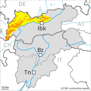
Distinct weak layers exist in the bottom section of the snowpack in particular above approximately 2000 m. Winter sport participants can release avalanches as before. These can penetrate deep layers and reach large size, especially on west, north and east facing slopes. Individual avalanche prone locations are to be found also on southeast, south and southwest facing slopes above approximately 2400 m. Caution is to be exercised in particular at transitions from a shallow to a deep snowpack, when entering gullies and bowls for example. Remotely triggered avalanches are possible.
Outgoing longwave radiation during the night will be severely restricted over a wide area. Individual small and, in isolated cases, medium-sized wet loose snow avalanches are possible below approximately 2200 m.
In addition gliding avalanches are possible. This applies especially on cut and grassy slopes below approximately 2400 m.
Snowpack
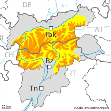
dp.7: snow-poor zones in snow-rich surrounding
Some snow will fall in some regions. The weather will be mild.
The snowpack remains prone to triggering. Avalanche prone weak layers exist in the bottom section of the snowpack on west, north and east facing slopes.
The surface of the snowpack will cool hardly at all during the overcast night and will already be soft in the early morning.
Tendency
Weakly bonded old snow requires caution. Single winter sport participants can release avalanches as before.
The weather will be sunny over a wide area. Slight increase in danger of wet avalanches as a consequence of warming during the day and solar radiation.
Danger level
treeline
Avalanche Problem
Persistent weak layer
Treeline
Wet snow
Weakly bonded old snow represents the main danger.
Avalanches can penetrate down to the ground and reach large size in isolated cases in particular on west, north and east facing slopes. In their paths avalanches can entrain the wet snow. This extends the avalanche runout distances. Until the temperature falls moist and wet avalanches are possible.
Snowpack
dp.1: deep persistent weak layer
Faceted weak layers exist in the old snowpack in particular on west, north and east facing slopes. The weather will be very mild. These weather conditions will foster a gradual weakening of the snowpack. The surface of the snowpack will cool hardly at all during the overcast night and will already be soft in the early morning.
Tendency
The weather will be cloudy. Some snow will fall in some regions.
Danger level
2000m
Avalanche Problem
Persistent weak layer
2000m
Wet snow
2200m
Weakly bonded old snow and wet snow require caution.
Avalanches can be released in the old snowpack and reach large size in particular on west, north and east facing slopes. This applies even in case of a single winter sport participant. The avalanche prone locations are to be found especially on west, north and east facing slopes above approximately 2000 m and in all aspects at elevated altitudes. Caution is to be exercised in particular at transitions from a shallow to a deep snowpack. Whumpfing sounds can indicate the danger. Remotely triggered avalanches are possible. In their paths avalanches can entrain the wet snow. This extends the avalanche runout distances.
As the moisture increases small to medium-sized wet avalanches are to be expected. In the event of an overcast night this applies in particular. Caution is to be exercised in particular below approximately 2200 m. The runout zones are to be treated with caution.
Snowpack
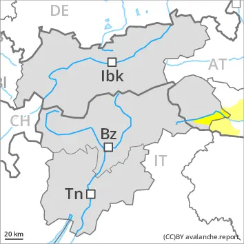
dp.1: deep persistent weak layer dp.10: springtime scenario
On Sunday it will be mild over a wide area. Outgoing longwave radiation during the night will be reduced at times.
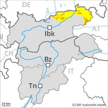
Shady slopes: The snowpack remains prone to triggering in some places. Distinct weak layers exist in the old snowpack in particular on west, north and east facing slopes.
Sunny slopes: The surface of the snowpack will only just freeze and will already soften in the late morning. The weather conditions gave rise to thorough wetting of the snowpack below approximately 2200 m.
Tendency
Weakly bonded old snow and wet snow are to be assessed with care and prudence.
Danger level
treeline
Avalanche Problem
Persistent weak layer
Treeline
Wet snow
2200m
Weakly bonded old snow requires caution. Wet snow requires caution.
Even single winter sport participants can release avalanches in some places. In particular shady slopes are dangerous, especially in areas close to the tree line, as well as above the tree line.
Outgoing longwave radiation during the night will be severely restricted over a wide area. Individual small and, in isolated cases, medium-sized wet loose snow avalanches are possible below approximately 2200 m.
In addition gliding avalanches are possible. This applies especially on cut and grassy slopes.
Snowpack
dp.1: deep persistent weak layer
Some snow will fall in some regions. The weather will be mild.
The snowpack remains unstable in some places. Avalanche prone weak layers exist in the bottom section of the snowpack on west, north and east facing slopes.
The surface of the snowpack will cool hardly at all during the overcast night and will already be soft in the early morning.
Tendency
Weakly bonded old snow requires caution. Single winter sport participants can release avalanches as before.
The weather will be sunny over a wide area. Slight increase in danger of wet avalanches as a consequence of warming during the day and solar radiation.
Danger level
2000m
Avalanche Problem
Persistent weak layer
2000m
Wet snow
2200m
Weakly bonded old snow requires caution. Wet snow requires caution.
Avalanches can be released in the old snowpack and reach large size. This applies even in case of a single winter sport participant. The avalanche prone locations are to be found in particular on steep west, north and east facing slopes above approximately 2000 m. Individual avalanche prone locations are to be found also on steep sunny slopes above approximately 2400 m. Caution is to be exercised in particular at transitions from a shallow to a deep snowpack, when entering gullies and bowls for example. In their paths avalanches can entrain the wet snow. This extends the avalanche runout distances. Remotely triggered avalanches are possible. Whumpfing sounds and the formation of shooting cracks when stepping on the snowpack serve as an alarm indicating the danger.
Outgoing longwave radiation during the night will be severely restricted over a wide area. Individual small and, in isolated cases, medium-sized wet loose snow avalanches are possible below approximately 2200 m.
Snowpack
dp.1: deep persistent weak layer dp.7: snow-poor zones in snow-rich surrounding
Some snow will fall in some localities. The weather will be mild.
Distinct weak layers exist in the old snowpack in particular on west, north and east facing slopes.
The surface of the snowpack will cool hardly at all during the overcast night and will already be soft in the early morning.
Tendency
Weakly bonded old snow requires caution. Single winter sport participants can release avalanches as before.
The weather will be sunny over a wide area. Slight increase in danger of wet avalanches as a consequence of warming during the day and solar radiation.
Danger level
2000m
Avalanche Problem
Persistent weak layer
2000m
Wet snow
2200m
Weakly bonded old snow and wet snow represent the main danger.
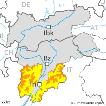
Avalanches can be released in the old snowpack and reach quite a large size on west, north and east facing slopes. This applies even in case of a single winter sport participant in some cases. The avalanche prone locations are to be found in particular above approximately 2000 m. Caution is to be exercised in particular at transitions from a shallow to a deep snowpack, when entering gullies and bowls for example. In their paths avalanches can entrain the wet snow. This extends the avalanche runout distances.
More small and medium-sized wet avalanches are possible below approximately 2200 m. The runout zones are to be treated with caution.
Snowpack
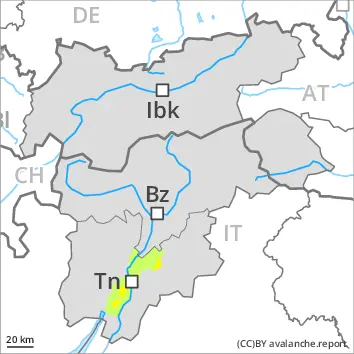
dp.1: deep persistent weak layer dp.10: springtime scenario
On Sunday it will be mild over a wide area. Outgoing longwave radiation during the night will be reduced at times.
Shady slopes: The snowpack remains prone to triggering in some places. Distinct weak layers exist in the old snowpack in particular on west, north and east facing slopes. This applies especially above approximately 2000 m.
Sunny slopes: The surface of the snowpack will only just freeze and will soften quickly. The weather conditions gave rise to thorough wetting of the snowpack below approximately 2200 m.
Tendency
Weakly bonded old snow and wet snow require caution.
Danger level
treeline
Avalanche Problem
Persistent weak layer
Treeline
Wet snow
Weakly bonded old snow requires caution.
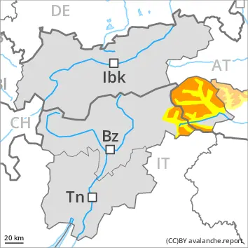
Weak layers exist in the snowpack in particular on west, north and east facing slopes. Avalanches can in very isolated cases be triggered in the old snowpack and reach medium size. In all aspects small and, in isolated cases, medium-sized wet avalanches are possible until the temperature drops.
Snowpack
dp.10: springtime scenario
Weak layers exist in the snowpack in particular on steep shady slopes. The spring-like weather conditions will give rise to increasing moistening of the snowpack over a wide area.
Tendency
The weather will be cloudy. Some snow will fall in some regions.
Danger level
treeline
Avalanche Problem
Persistent weak layer
Treeline
Wet snow
Weak layers in the old snowpack can be released in isolated cases. The danger of wet avalanches will increase a little during the day.
Avalanches can in isolated cases be released in the old snowpack and reach medium size on west, north and east facing slopes. This applies in case of a single winter sport participant. In their paths avalanches can entrain the wet snow.
As a consequence of warming during the day individual wet avalanches are possible.
Snowpack
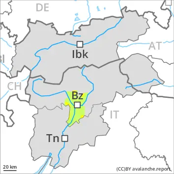
dp.1: deep persistent weak layer dp.10: springtime scenario
Distinct weak layers exist in the old snowpack in particular on west, north and east facing slopes.
Outgoing longwave radiation during the night will be reduced in some case. The weather conditions as the day progresses will give rise to gradual softening of the snowpack.
Tendency
Weakly bonded old snow and wet snow require caution.