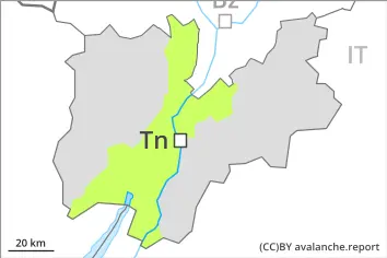
Danger level
 | 2000m |
|  |
|  |

![]()
Weakly bonded old snow requires caution.
Weakly bonded old snow requires caution.
Avalanches can be released in the old snowpack, even by a single winter sport participant. They can in isolated cases release deeper layers of the snowpack and reach quite a large size. Avalanche prone locations are to be found especially above approximately 2000 m. These avalanche prone locations are to be found in particular in northwest to north to northeast facing aspects. Caution is to be exercised in particular on steep shady slopes, as well as at transitions from a shallow to a deep snowpack, when entering gullies and bowls for example.
In the late morning the likelihood of slab avalanches being released will increase in particular on steep south and southwest facing slopes below the tree line.
As a consequence of warming during the day individual mostly small wet loose snow avalanches are possible.
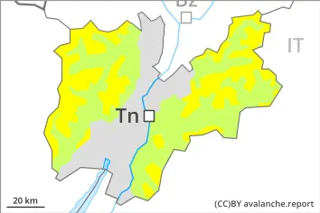
Snowpack
dp.1: deep persistent weak layer
dp.10: springtime scenario
Shady slopes: Distinct weak layers exist in the bottom section of the snowpack in particular on northwest, north and northeast facing slopes. This applies especially above approximately 2000 m.
Outgoing longwave radiation during the night was reduced over a wide area. Below approximately 2000 m and steep sunny slopes: The old snowpack will be moist. The surface of the snowpack will freeze very little and will already be soft in the early morning.
In some localities 2 to 5 cm of snow will fall in the late morning, especially above approximately 1800 m.
Tendency
Over a wide area 15 to 30 cm of snow, and even more in some localities, will fall until Sunday. The strong wind will transport the new snow. Fresh wind slabs are prone to triggering on steep shady slopes. The avalanche danger will increase.