Wind slabs and weakly bonded old snow require caution.
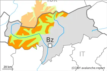
In the course of the day further wind slabs will form in particular on northwest, east and southeast facing slopes. This applies in gullies and bowls, and behind abrupt changes in the terrain above approximately 2000 m. The fresh wind slabs can be released easily. or in isolated cases naturally,. Avalanches can reach medium size in isolated cases. The prevalence of avalanche prone locations and likelihood of triggering will increase with altitude.
Avalanches can be released in near-ground layers and reach large size in isolated cases. The avalanche prone locations are to be found in particular on very steep west, north and east facing slopes above approximately 2000 m. Caution is to be exercised in particular at transitions from a shallow to a deep snowpack, when entering gullies and bowls for example.
In addition small and, in isolated cases, medium-sized moist loose snow avalanches are possible, in the event of solar radiation in particular on extremely steep slopes.
Snowpack
dp.6: cold, loose snow and wind dp.1: deep persistent weak layer
20 to 40 cm of snow, and even more in some localities, has fallen since Saturday. As a consequence of a strengthening wind from westerly directions, further wind slabs will form on Monday in gullies and bowls and behind abrupt changes in the terrain. They will be deposited on soft layers.
Avalanche prone weak layers exist in the bottom section of the snowpack on west, north and east facing slopes. This applies above approximately 2000 m.
Below approximately 2000 m and steep sunny slopes: The old snowpack will be moist.
Tendency
Wind slabs and weakly bonded old snow require caution.
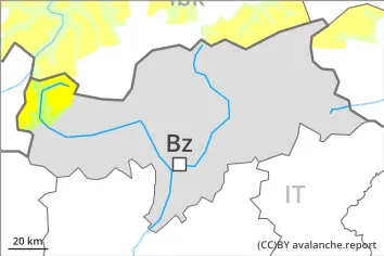
In the course of the day mostly small wind slabs will form in particular on northwest, east and southeast facing slopes. This applies in gullies and bowls, and behind abrupt changes in the terrain above the tree line. The fresh wind slabs can be released very easily. Restraint should be exercised because avalanches can sweep people along and give rise to falls. The prevalence of avalanche prone locations and likelihood of triggering will increase with altitude.
Avalanches can be released in near-ground layers and reach large size in isolated cases. The avalanche prone locations are to be found in particular on very steep west, north and east facing slopes above approximately 2000 m. Such avalanche prone locations are rare but are barely recognisable. Caution is to be exercised in particular at transitions from a shallow to a deep snowpack, when entering gullies and bowls for example.
Especially in the regions exposed to heavier precipitation mostly small loose snow avalanches are possible as a consequence of warming during the day and solar radiation, in particular on extremely steep slopes.
Snowpack
dp.6: cold, loose snow and wind dp.7: snow-poor zones in snow-rich surrounding
Over a wide area 5 to 15 cm of snow, and even more in some localities, has fallen since Saturday. As a consequence of a strengthening westerly wind, wind slabs will form on Monday in gullies and bowls and behind abrupt changes in the terrain. The fresh wind slabs will be deposited on soft layers.
Avalanche prone weak layers exist in the bottom section of the snowpack on west, north and east facing slopes. This applies above approximately 2000 m.
Below approximately 2000 m and steep sunny slopes: The old snowpack will be moist.
Tendency
Wind slabs and weakly bonded old snow require caution.
Danger level
2000m
Avalanche Problem
Persistent weak layer
2000m
Wind slab
2000m
Wind slabs and weakly bonded old snow require caution.
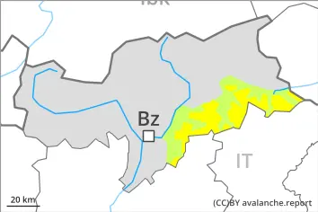
Avalanches can in some cases be released in near-ground layers and reach medium size. The avalanche prone locations are to be found in particular on very steep west, north and east facing slopes above approximately 2000 m. Such avalanche prone locations are rare but are barely recognisable. Caution is to be exercised in particular at transitions from a shallow to a deep snowpack, when entering gullies and bowls for example.
The fresh wind slabs are in some cases prone to triggering on very steep shady slopes at elevated altitudes. They can in some cases be released by a single winter sport participant and reach medium size. Such avalanche prone locations are to be found especially adjacent to ridgelines.
On extremely steep slopes small loose snow avalanches are possible, in the event of solar radiation in particular.
Snowpack
dp.7: snow-poor zones in snow-rich surrounding dp.6: cold, loose snow and wind
15 to 25 cm of snow, and even more in some localities, has fallen since Saturday. As a consequence of a moderate to strong wind, sometimes avalanche prone wind slabs formed in particular adjacent to ridgelines and in pass areas. They are lying on the unfavourable surface of an old snowpack on shady slopes.
Avalanche prone weak layers exist in the bottom section of the snowpack on west, north and east facing slopes. This applies above approximately 2000 m.
Below approximately 2000 m and steep sunny slopes: The old snowpack will be moist.
Tendency
Wind slabs and weakly bonded old snow require caution.
Danger level
2000m
Avalanche Problem
Persistent weak layer
2000m
Weakly bonded old snow requires caution.
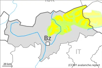
Avalanches can in isolated cases be released in the old snowpack and reach medium size. The avalanche prone locations are to be found in particular on very steep west, north and east facing slopes above approximately 2000 m. Caution is to be exercised in particular at transitions from a shallow to a deep snowpack, when entering gullies and bowls for example.
In addition the small wind slabs are prone to triggering in isolated cases, in particular adjacent to ridgelines on shady slopes at elevated altitudes. These can in isolated cases be released by people.
Snowpack
dp.7: snow-poor zones in snow-rich surrounding dp.6: cold, loose snow and wind
Over a wide area 5 to 15 cm of snow, and even more in some localities, has fallen since Saturday. The wind was moderate in the vicinity of peaks. The fresh wind slabs are lying on the unfavourable surface of an old snowpack in particular on near-ridge shady slopes at elevated altitudes.
Above approximately 2000 m: Avalanche prone weak layers exist in the bottom section of the snowpack on west, north and east facing slopes. Towards its surface, the snowpack consists of faceted crystals. This applies on shady slopes.
Below approximately 2000 m and steep sunny slopes: The old snowpack will be moist.
Tendency
Weakly bonded old snow requires caution. As a consequence of a sometimes strong northerly foehn wind, sometimes avalanche prone wind slabs will form.
Danger level
Low avalanche danger will prevail.
On extremely steep slopes small moist and wet snow slides are possible, in the event of solar radiation in particular. Avalanches can be released, in particular by large loads, but they will be small in most cases. Individual avalanche prone locations are to be found on steep shady slopes at high altitude.
Snowpack
dp.10: springtime scenario
Shady slopes: Isolated avalanche prone weak layers exist in the old snowpack in particular on northwest, north and northeast facing slopes.
Sunny slopes: The old snowpack will be moist. The weather conditions will give rise to thorough wetting of the snowpack at low and intermediate altitudes.