Significant warming: Increase in danger of wet avalanches. Weakly bonded old snow requires caution.
Mostly small wet snow slides and avalanches are possible in the late morning. These avalanche prone locations are to be found on steep slopes of all aspects below approximately 2200 m. As a consequence of warming during the day and the solar radiation, the likelihood of wet snow slides and avalanches being released will increase gradually also at high altitude. This applies especially on very steep east, south and west facing slopes. Weak layers in the old snowpack can be released in some places by individual winter sport participants. This applies especially on very steep shady slopes above approximately 2200 m, and on very steep east and west facing slopes above approximately 2400 m. As a consequence of warming the prevalence and size of these avalanche prone locations will increase as the day progresses. Caution is to be exercised in particular at transitions from a shallow to a deep snowpack, when entering gullies and bowls for example. In addition the wind slabs of the last few days are capable of being triggered in very isolated cases still. This applies on very steep shady slopes at elevated altitudes, and adjacent to ridgelines. Backcountry tours, off-piste skiing and ascents to alpine cabins should be concluded early.
Snowpack
dp.10: springtime scenario dp.1: deep persistent weak layer
The surface of the snowpack will cool hardly at all during the overcast night. Sunshine and high temperatures will give rise as the day progresses to rapid moistening of the snowpack. The snowpack will become increasingly prone to triggering. Faceted weak layers exist in the old snowpack, in particular on shady slopes above approximately 2200 m, as well as on east and west facing slopes above approximately 2400 m. The weather conditions will bring about a weakening of the weak layers as the day progresses. The wind slabs of the last few days have bonded quite well with the old snowpack. They can only be released in isolated cases.
Tendency
Tuesday: Wind and new snow. Fresh wind slabs require caution.
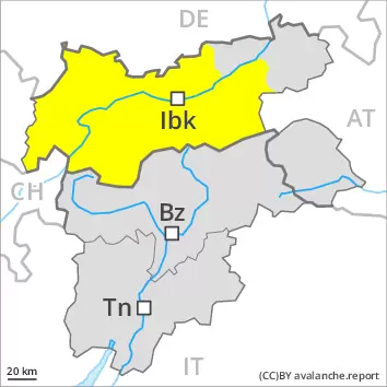
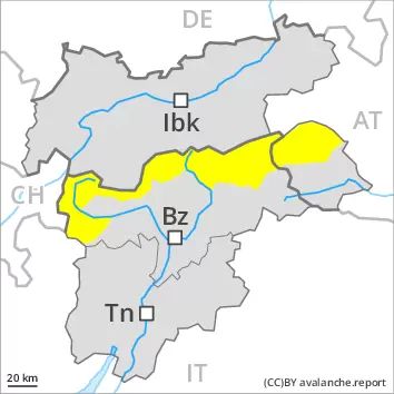
AM Danger level
Avalanche Problem
Wet snow
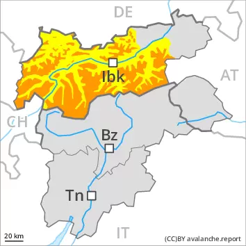
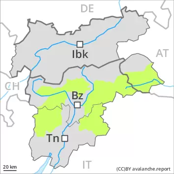
PM Danger level
Avalanche Problem
Wet snow
Significant warming: Increase in danger of moist and wet snow slides.
Most and wet avalanches can be released by a single winter sport participant, but they will be small in most cases. These avalanche prone locations are to be found on steep slopes of all aspects. As a consequence of warming during the day and the solar radiation, the likelihood of wet snow slides and avalanches being released will increase gradually also at high altitude.
Snowpack
dp.10: springtime scenario
The surface of the snowpack will cool hardly at all during the overcast night. Sunshine and high temperatures will give rise as the day progresses to rapid moistening of the snowpack. The snowpack will become increasingly prone to triggering.
Tendency
Tuesday: Wind and new snow. Fresh wind slabs require caution.
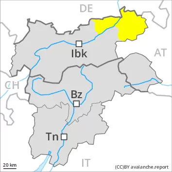
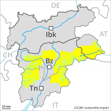
AM Danger level
2400m
Avalanche Problem
Wind slab
2400m
Persistent weak layer
2200m
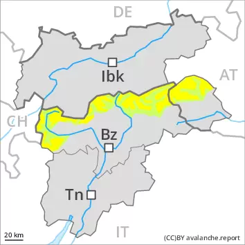
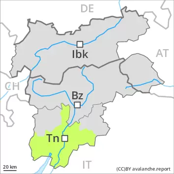
PM Danger level
2800m
Avalanche Problem
Wet snow
2800m
Persistent weak layer
2200m
Wind slabs and weakly bonded old snow in the high Alpine regions. As a consequence of warming during the day and the solar radiation, the likelihood of snow slides and avalanches being released will increase gradually.
Late morning: The fresh wind slabs are in individual cases still prone to triggering. These avalanche prone locations are to be found in particular on northwest to north to east facing aspects above approximately 2400 m, especially in gullies and bowls, and behind abrupt changes in the terrain. Weak layers in the old snowpack can be released in isolated cases by individual winter sport participants. The avalanche prone locations are to be found in particular on very steep northwest, north and east facing slopes above approximately 2200 m. Caution is to be exercised in particular at transitions from a shallow to a deep snowpack, when entering gullies and bowls for example.
Midday and afternoon: As a consequence of warming during the day and the solar radiation, the likelihood of slab avalanches being released will increase a little. In addition the danger of wet loose snow avalanches will increase. This applies on extremely steep slopes in all aspects below approximately 2400 m, in particular on very steep east, south and west facing slopes below approximately 2800 m. Backcountry tours, off-piste skiing and ascents to alpine cabins should be concluded timely.
Snowpack
dp.10: springtime scenario dp.1: deep persistent weak layer
The wind slabs of the last few days are in some cases prone to triggering on very steep shady slopes above approximately 2400 m. Faceted weak layers exist in the old snowpack, in particular on shady slopes above approximately 2200 m, as well as on east and west facing slopes above approximately 2400 m.
The surface of the snowpack is frozen, but not to a significant depth and will soften quickly. Sunshine and high temperatures will give rise as the day progresses to a loss of strength within the snowpack. The conditions will bring about a weakening of the weak layers. The snowpack will become increasingly prone to triggering.
Tendency
Tuesday: Wind and new snow. Fresh wind slabs require caution.
AM Danger level
PM Danger level
2800m
Avalanche Problem
Wet snow
2800m
Significant warming at high altitude: Increase in danger of wet avalanches in the course of the day.
Late morning: The mostly small wind slabs of the last few days can be released by a single winter sport participant in isolated cases on very steep shady slopes above approximately 2400 m.
Midday and afternoon: As a consequence of warming during the day and the solar radiation, the likelihood of wet snow slides and avalanches being released will increase gradually. This applies in all aspects below approximately 2400 m, in particular on very steep east, south and west facing slopes below approximately 2800 m. Backcountry tours, off-piste skiing and ascents to alpine cabins should be concluded timely.
Snowpack
dp.10: springtime scenario
The surface of the snowpack is frozen, but not to a significant depth. Sunshine and high temperatures will give rise as the day progresses to rapid softening of the snowpack. The snowpack will become increasingly prone to triggering. Faceted weak layers exist in the old snowpack, in particular on shady slopes above approximately 2200 m, as well as on east and west facing slopes above approximately 2400 m. The weather conditions will bring about a weakening of the weak layers as the day progresses. The wind slabs of the last few days are in individual cases still prone to triggering on very steep shady slopes above approximately 2400 m.
Tendency
Tuesday: Wind and new snow. Fresh wind slabs require caution.
Danger level
Fresh wind slabs require caution.
More recent wind slabs are rather small and can only be released in isolated cases. Avalanches can additionally in some places be released in the weakly bonded old snow at high altitude. These avalanche prone locations are to be found in particular on very steep shady slopes and at transitions from a shallow to a deep snowpack. They are very rare but are difficult to recognise.
Snowpack
dp.6: cold, loose snow and wind dp.1: deep persistent weak layer
In very isolated cases weak layers exist in the centre of the snowpack, in particular on steep shady slopes at high altitude. The weather conditions as the day progresses will give rise to moistening of the snowpack, in particular at intermediate and high altitudes. In particular at low and intermediate altitudes only a small amount of snow is lying for the time of year. Some snow will fall in the evening in some localities.
Tendency
Above approximately 1500 m snow will fall on Tuesday over a wide area. Slight increase in avalanche danger as a consequence of new snow and wind.
AM Danger level
PM Danger level
Avalanche Problem
Wet snow
Increase in danger of wet snow slides in the course of the day.
The early morning will see favourable conditions generally. As a consequence of warming during the day and the solar radiation, the likelihood of wet loose snow slides being released will increase a little. This applies on extremely steep slopes in all aspects. The avalanche prone locations are rather rare. Restraint should be exercised because avalanches can sweep people along and give rise to falls.
Snowpack
dp.10: springtime scenario
A little snow is lying. The snowpack will be generally stable. Sunshine and high temperatures will give rise as the day progresses to gradual softening of the snowpack. The snowpack will become increasingly wet all the way through.