Wind slabs and weakly bonded old snow represent the main danger.
Weak layers in the old snowpack can be released in some places by individual winter sport participants. This applies in particular on very steep shady slopes above approximately 2200 m, as well as on very steep east facing slopes above approximately 2400 m. Caution is to be exercised at transitions from a shallow to a deep snowpack, when entering gullies and bowls for example. As a consequence of new snow and a sometimes strong wind, wind slabs will form over a wide area. These can be released, even by small loads in isolated cases. Avalanche prone locations are to be found in particular on very steep northwest, north and east facing slopes above approximately 2200 m, especially adjacent to ridgelines. The number and size of avalanche prone locations will increase with altitude. As a consequence of the rain mostly small wet snow slides and avalanches are possible below approximately 1800 m. Individual small loose snow avalanches are possible.
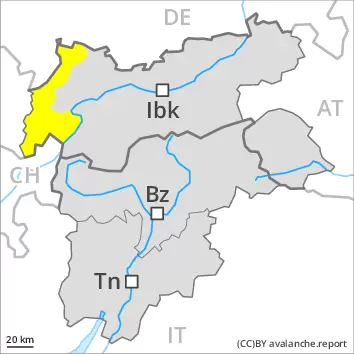
Snowpack
dp.6: cold, loose snow and wind dp.1: deep persistent weak layer
Over a wide area 20 to 30 cm of snow will fall on Tuesday above approximately 1800 m. As a consequence of new snow and a sometimes strong wind, extensive wind slabs will form in particular adjacent to ridgelines on northwest, north and east facing slopes. These are lying on soft layers on steep shady slopes at high altitudes and in high Alpine regions. Faceted weak layers exist in the old snowpack, especially on shady slopes above approximately 2200 m, as well as on east facing slopes above approximately 2400 m. The rain will give rise to increasing and thorough wetting of the snowpack at low and intermediate altitudes.
Tendency
Wednesday: In some regions some new snow. Wind slabs require caution.
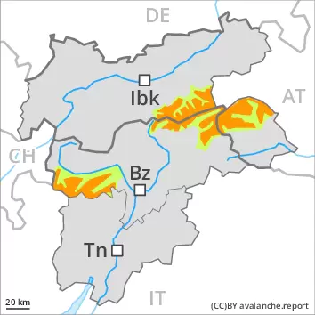
Danger level
2200m
Avalanche Problem
Wind slab
2200m
Persistent weak layer
2200m
Wind slabs and weakly bonded old snow represent the main danger.
Fresh wind slabs can be released even by a single winter sport participant. They are to be avoided in particular in steep terrain. The avalanche prone locations are to be found in particular on northwest to north to east facing aspects above approximately 2200 m and adjacent to ridgelines and in gullies and bowls. The avalanche prone locations are sometimes covered with new snow and are barely recognisable because of the poor visibility. As a consequence of the strong northerly wind the prevalence and size of these avalanche prone locations will increase as the day progresses. At elevated altitudes the avalanche prone locations are more prevalent. Weak layers in the old snowpack can be released in some places by individual winter sport participants. This applies in particular on very steep shady slopes above approximately 2200 m, as well as on very steep east facing slopes above approximately 2400 m. Caution is to be exercised at transitions from a shallow to a deep snowpack, when entering gullies and bowls for example. Small loose snow avalanches are possible.
Snowpack
dp.6: cold, loose snow and wind dp.1: deep persistent weak layer
Over a wide area 20 to 40 cm of snow will fall on Tuesday above approximately 1800 m. As a consequence of new snow and a sometimes strong wind, sometimes avalanche prone wind slabs will form. These are lying on soft layers on steep shady slopes at high altitudes and in high Alpine regions. Faceted weak layers exist in the old snowpack, especially on shady slopes above approximately 2200 m, as well as on east facing slopes above approximately 2400 m. The rain will give rise to increasing and thorough wetting of the snowpack at low and intermediate altitudes.
Tendency
Wednesday: In some regions some new snow. Wind slabs require caution.
Danger level
treeline
Avalanche Problem
Wind slab
Treeline
New snow and wind slabs are to be assessed with care and prudence.
The new snow and wind slabs can be released easily, even by a single winter sport participant,. The avalanche prone locations are to be found in all aspects and adjacent to ridgelines and in gullies and bowls. Caution is to be exercised in particular on steep shady slopes. The avalanche prone locations are sometimes covered with new snow and are barely recognisable because of the poor visibility. At elevated altitudes the avalanche prone locations are more prevalent. As a consequence of the strong northerly wind the prevalence and size of these avalanche prone locations will increase in the evening. Avalanches can additionally in isolated cases be released in the old snowpack in particular on steep, little used shady slopes. The avalanche prone locations are to be found in particular on very steep northwest, north and east facing slopes above approximately 2200 m. Caution is to be exercised in particular at transitions from a shallow to a deep snowpack. Backcountry touring and other off-piste activities call for experience in the assessment of avalanche danger and caution.
Snowpack
Over a wide area 15 to 40 cm of snow, and even more in some localities, will fall on Tuesday above approximately 1800 m. As a consequence of a strong to storm force wind from southwesterly directions, sometimes deep wind slabs will form by the early morning. Over a wide area new snow and wind slabs are lying on the smooth surface of an old snowpack. The fresh snow as well as the wind slabs that are forming during the snowfall can be released easily or naturally in particular on steep shady slopes. Caution is to be exercised adjacent to ridgelines, as well as in gullies and bowls. The snowpack will become increasingly prone to triggering. Faceted weak layers exist in the old snowpack, in particular on shady slopes above approximately 2200 m, as well as on east and west facing slopes above approximately 2400 m.
Tendency
As a consequence of falling temperatures and the strong northerly wind, the snowpack can not consolidate on Wednesday. New snow and wind slabs are to be assessed with care and prudence.
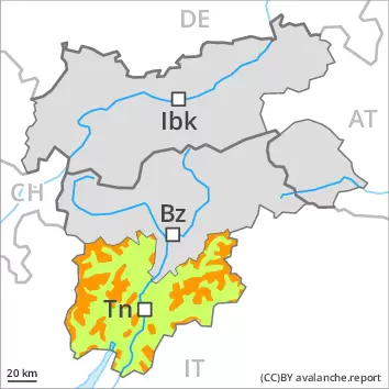
Danger level
2200m
Avalanche Problem
Wind slab
2200m
Persistent weak layer
2200m
Wind slabs and weakly bonded old snow represent the main danger.
Fresh wind slabs can be released even by a single winter sport participant. They are to be avoided in particular in steep terrain. The avalanche prone locations are to be found in particular on northwest to north to east facing aspects above approximately 2200 m and adjacent to ridgelines and in gullies and bowls. The avalanche prone locations are sometimes covered with new snow and are barely recognisable because of the poor visibility. As a consequence of the strong northerly wind the prevalence and size of these avalanche prone locations will increase as the day progresses. At elevated altitudes the avalanche prone locations are more prevalent. Weak layers in the old snowpack can be released in some places by individual winter sport participants. This applies in particular on very steep shady slopes above approximately 2200 m, as well as on very steep east facing slopes above approximately 2400 m. Caution is to be exercised at transitions from a shallow to a deep snowpack, when entering gullies and bowls for example. Small loose snow avalanches are possible.
Snowpack
dp.6: cold, loose snow and wind dp.1: deep persistent weak layer
Over a wide area 10 to 20 cm of snow, and even more in some localities, will fall on Tuesday above approximately 1800 m. As a consequence of new snow and a sometimes strong wind, sometimes avalanche prone wind slabs will form. These are lying on soft layers on steep shady slopes at high altitudes and in high Alpine regions. Faceted weak layers exist in the old snowpack, especially on shady slopes above approximately 2200 m, as well as on east facing slopes above approximately 2400 m. The rain will give rise to increasing and thorough wetting of the snowpack at low and intermediate altitudes.
Tendency
Wednesday: In some regions some new snow. Wind slabs require caution.
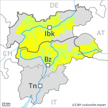
Danger level
Avalanche Problem
Wind slab
Fresh wind slabs require caution.
As a consequence of new snow and a sometimes strong wind, mostly small wind slabs will form on Tuesday in particular at elevated altitudes. The fresh wind slabs can be released by a single winter sport participant in isolated cases in particular on steep shady slopes. The wind slabs are to be avoided in particular in terrain where there is a danger of falling. Caution is to be exercised adjacent to ridgelines and in gullies and bowls. The avalanche prone locations are rather rare but are barely recognisable because of the poor visibility.
Snowpack
dp.6: cold, loose snow and wind
In some localities up to 10 cm of snow will fall on Tuesday. The fresh snow as well as the small wind slabs that are forming during the snowfall will be deposited on the quite favourable surface of an old snowpack. As a consequence of a gathering strong northerly wind, further wind slabs will form in the course of the day. Hardly any weak layers exist in the old snowpack. Snow depths vary greatly, depending on the infuence of the wind.
Tendency
As a consequence of falling temperatures and the strong northerly wind, the snowpack can not consolidate on Wednesday. Fresh wind slabs are to be avoided.
Danger level
Fresh wind slabs require caution.
As a consequence of new snow and a sometimes strong wind, wind slabs will form over a wide area. These can in very isolated cases be released. Avalanche prone locations are to be found in particular on extremely steep shady slopes at high altitude,, also adjacent to ridgelines. As a consequence of the rain mostly small wet snow slides are possible below approximately 1800 m.
Snowpack
dp.6: cold, loose snow and wind dp.3: rain
Over a wide area 20 to 30 cm of snow will fall on Tuesday above approximately 1800 m. As a consequence of new snow and a sometimes strong wind, extensive wind slabs will form in particular adjacent to ridgelines on northwest, north and east facing slopes. The rain will give rise to increasing and thorough wetting of the snowpack at low and intermediate altitudes.
Tendency
Wednesday: In some regions some new snow. Wind slabs require caution.