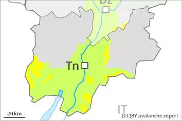
Danger level
 | treeline |
|  |
|  | ||||
|  | |


![]()
The new snow and wind slabs represent the main danger.
Restraint is advisable on this first sunny day.
The fresh snow and the wind slabs formed by the strong wind can be released easily, even by a single winter sport participant,. The avalanche prone locations are to be found in steep terrain above the tree line. At elevated altitudes the likelihood of avalanches being released is greater. Avalanches can reach quite a large size, in the regions exposed to a lot of new snow especially.
Individual natural avalanches are not ruled out, in particular on wind-loaded slopes at elevated altitudes.
On extremely steep slopes more loose snow avalanches are to be expected, in the event of prolonged bright spells in particular. In addition in particular in the regions exposed to heavier precipitation, individual gliding avalanches are possible.
Experience and restraint are required.
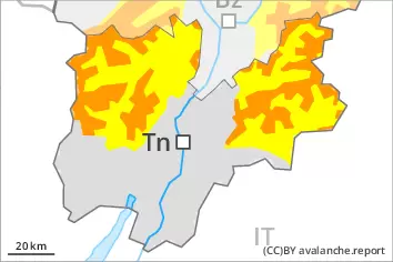
Snowpack
dp.6: cold, loose snow and wind
dp.2: gliding snow
The snowpack will be in some cases prone to triggering.
Over a wide area 20 to 50 cm of snow, and even more in some localities, has fallen since Wednesday. As a consequence of the sometimes storm force wind the wind slabs have increased in size once again on Friday. The various wind slabs have bonded poorly together. In some places new snow and wind slabs are lying on soft layers, in particular at elevated altitudes.
Isolated avalanche prone weak layers exist in the old snowpack on very steep shady slopes, especially at elevated altitudes.
Tendency
Sunday: The new snow and wind slabs remain prone to triggering. Caution and restraint are required.